 East Mercer Street: No Trespassing
By Bryan Tagas
For several decades the owners of two waterfront properties in Madison Park have taken for their private use the public road end which sits between their two properties. By doing so, they have excluded the public from what is publicly owned waterfront. This encroachment on the public right-of-way, which may have begun in the 1950s or before, was initially accomplished through the planting of hedges and other landscaping across the road end, thereby blocking physical access to the site and effectively eliminating the public’s view of Lake Washington from the roadway.
Although the City became aware of these illegal encroachments late in the last century, it has not required either that the obstructions be removed or that the waterfront be returned to public use. Ironically, the unsanctioned action of the former owners of these two properties in blocking off the road end provides the current owners with the ongoing right to keep out the public. Because this road-end encroachment has been “grandfathered” under current City rules, all that the abutting property owners have to do now is pay an annual fee for their continued private use of this public space. And that annual fee is not based on the current assessed value of the surrounding properties.
The public property in question is the E. Mercer Street road end, which is located off of 39th Avenue E. in the area several houses to the north of the E. Harrison Street public road end, better known as Hidden Beach. This section of 39thAvenue, just south of the Seattle Tennis Club, is known to locals as the bottom of “Devil’s Dip.” Although Mercer Street actually peters out well to the west of 39th, its stub street end on Lake Washington represents more than a quarter acre of prime Madison Park waterfront. At 120-feet wide, it is twice the width of the Lake Washington lot which abuts the road end on the south side.
 Private encroachment on public property usually generates a significant level of public controversy and media attention. Just down the road and around the corner from the E. Mercer Street road end, for example, lies Viretta Park. Many will recall the public outcry in the 1990s that resulted from the supposed encroachment of a neighboring homeowner, Starbucks CEO Howard Schultz, into the Park’s public space with his landscaping, driveway, and wall. That brouhaha ultimately involved the City Council and the Courts, and Schultz ultimately exited the property. Currently, there is well publicized dustup underway in Laurelhurst over a hedge which only partially obstructs a waterfront road end there. That encroachment benefits a property once owned by Bill Gates, which is currently owned by his sister, Libby, and her husband. Several Laurelhurst residents are up in arms that even a minor private encroachment on that public space has been allowed to continue.
The conversion of the E. Mercer St. road end from public space to private use has never received the kind of media focus that has been generated by these other encroachments. This may simply be due to the fact that very few Madison Parkers are aware that the property in question even belongs to the public. One longtime resident, who lives just down the street from the road end, tells us he cannot remember the public ever having access to the site in the more than 50 years he’s lived there. When a group of community activists from Madrona attempted to get the City to return it to public use several years ago, the E. Mercer St. road end did achieve a bit of notoriety; but there was virtually no media coverage of the group’s efforts. In any event, the City rejected the group’s public-use challenge.
We made a Public Disclosure request to the Seattle Department of Transportation (SDOT) to learn the process by which the public has been legally excluded from this public waterfront site. We also questioned Brian de Place, SDOT’s current Manager for Right-of-Way Management/Street Use, about the situation. What we learned from our investigation is that while the City’s official policy is that “the highest and best use of these street ends is for public use,” there are exceptions. The E. Mercer St. road end is probably as extreme of an exception as is possible, since it involves the complete abandonment of public use.
Here’s a little history of the City’s attempt over the past few years to deal with private encroachments on waterfront road ends. There are 149 such road ends within the City limits, six of which are located in Madison Park. In 1996, the Seattle City Council passed a resolution stating that it is City policy that “Shoreline street ends…shall be preserved as public rights-of-way.” The resolution, however, was strangely silent on the issue of whether existing private encroachments on these road ends must be removed, and no procedure was established for determining when private usage of a public road end could be permitted.
This created an ambiguous situation, which the Council sought to clarify in a 1999 ordinance, which reaffirmed that the City’s goal was to “keep adjacent property owners from encroaching on the public’s shoreline street ends,” but then went on to outline the procedure by which existing encroachments would be permitted through the payment of an annual fee. The amount of the fee was to be based on the size of the encroachment in square feet, the percentage likelihood of the public wanting to use the site (the demand/probability factor), the extent to which any barrier on the site impeded public access (including visual access), and the estimated value of the land per square foot. An annual rate of return (the “land capitalization rate”) was also to be factored in.
The idea was to use the fees that are collected to fund the City’s shoreline street-end management program, including paying for improvements, the inspection of road ends, and the notification to property owners of any encroachments. The SDOT was directed to establish a policy for enforcing the new ordinance, which it did in 2000.
Now, to return to the E. Mercer St. road end. In July of 2000, the City notified the encroaching property owners to the north and south of the road end that they could either apply for a Shoreline Street End Permit or remove the barriers that existed to the public right of way. The letter from SDOT’s Street Use Division included this statement of the City’s philosophy: “Although the ultimate goal is to remove all private uses of these street ends, the permit process acknowledges some private uses will continue. This permit process provides a means to review and approve private uses, as appropriate, until the property can be developed for public use.” Both property owners chose to keep their barriers in place, and from that point forward they have been paying annually for the continued right to block public access to the waterfront at E. Mercer.
 Initially, the annual private-use fee amounts were $28,080 and $21,600 respectively, the property owner to the north having encroached on 7,800 sq. ft. of public shoreline and the southern owner having encroached on 4,800 sq. ft. It appears that these fees were not adjusted in any way for seven years, but in 2007 the amounts were set at $35,100 and $21,600 respectively; and those are the annual fees the property owners are paying today. The increase in the fee for the northern property owner was based on the City’s evaluation that the barrier to public access had increased from 80% in 2000 to 100% by 2007.
It is not clear, however, that the City has correctly determined the permit-fee amounts for the E. Mercer Street encroachments. According to the City’s stated guidelines for calculating the permit fees, “values are generally based on averages of assessed values for waterfront properties within like areas.” But SDOT in 2000 assigned a value of only $90 per sq. ft. to the area of encroachment. This assumed land value was never updated when any of the ten subsequent permit renewals occurred, and it is significantly lower than the property values set by the King County Assessor for the neighboring properties. Indeed, the 2010 assessments for the 14 waterfront properties in Madison Park along 39th Avenue E. average $467 per sq. ft.
The 12,600 sq. ft. of public property at the E. Mercer Street road end, based on King County’s assessment of the “like properties” in the neighborhood, would be valued at almost $6 million. However, based on its permit calculations, SDOT’s estimate of the value is only $1.1 million. Quite clearly, if SDOT used a factor based on the actual average assessed value for the area’s waterfront properties, the permit fees of the encroaching property owners would be substantially higher than what the City is receiving.
SDOT’s Brian de Place acknowledges that the City’s estimate of the road end’s value for permit purposes is not in line with current property values. He states that under the current ordinance, the City is not allowed to use King County Assessor data to determine value or to update values once the “City Assessor” has made the original site-specific determination, in this case ten years ago. A proposed change in the ordinance to be introduced next year, de Place notes, will allow the City to increase the permit fee amounts to take into consideration the current values of surrounding properties. If the existing $467 per sq. ft. surrounding-property value were used in calculating the encroachment-permit fees, the annual amounts paid by the two property owners would increase to $182,130 and $112,080 respectively.
 According to one of the abutting-property owners, however, the road end is not being undervalued by the City. He says the property could never be built on because a house there would violate current waterfront building regulations concerning setbacks from the waterline and protection of neighbors’ views. If the property could not be built on, he argues, it has little or no value; and the City should therefore not look to the value of neighboring properties when determining the permit fee.
He also points out that neither he nor the property owner to the south created the situation at the road end. They each bought their properties when the encroachments had already occurred. After reading a draft of this posting he responded that “I think the issue is far more nuanced than you make it out to be.” He noted, for example, that the City has no money for upkeep of another public road end, there’s inadequate parking available on the street, and past illegal activity at Hidden Beach offers a warning of what the neighbors can expect if E. Mercer St. is opened up. Moreover, the City is getting some badly needed funds for the street-end program as a result of encroachment-permit revenues.
“I get charged a fee, and I pay it,” he told us. “I don’t control the fee, I don’t control how SDOT works, I don’t control who runs the city. I just get my bill and pay it, just like I pay my property taxes and my light bill. After I bought the house the city imposed the policy you are writing about. I was given the choice of paying or not paying. I chose to pay. So I think that a journalistic slant that tries to make it look like the homeowners cut some side deal with the city implies proactive intent on the homeowner’s part. The truth is that the city changed its policy and notified us and gave us a choice.”
 The City, of course, could change its policy again and decide to open the road end to public use. That is the ultimate goal of the street-end policy, after all. But selling the land to the surrounding property owners is not an option. The idea has been broached, but according to de Place, selling the land could only occur after a “street vacation” in which the City would first have to certify that the site could never be used for public purposes. That’s not going to happen, he told us.
For now SDOT is happy just to collect its permit fees and look forward to receiving even higher revenue from the road end when the new ordinance is finally adopted. De Place notes that the goal of City policy is being advanced by the permit process, which since its adoption in 2000 has resulted in the reduction of shoreline encroachments from 93 to just 34. He expects that trend to continue. If so, perhaps one day there will be a sixth road end in Madison Park that the public can not only own but enjoy.
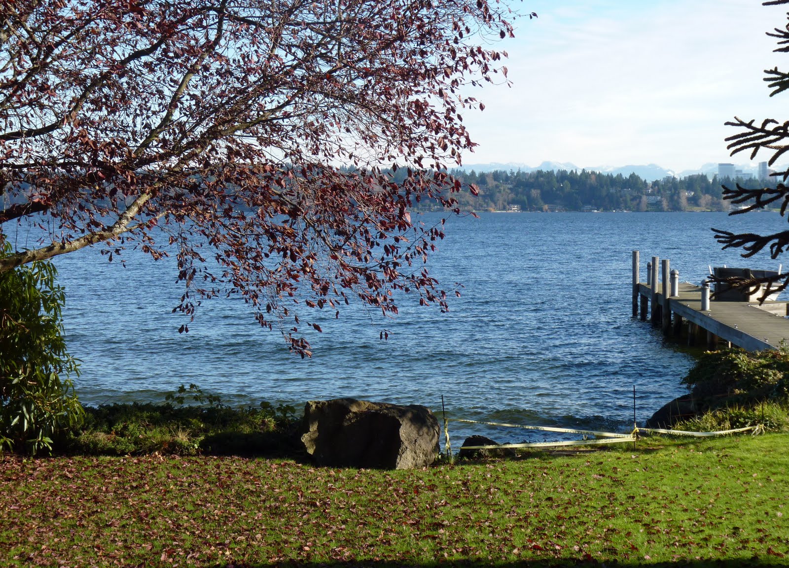
 [Graphics: Upper photo shows the view from the southern portion of the roadend. Aerial photo, from Google Earth, shows the extent of the public property on the waterside, currently enclosed by private property owners. The middle photos show the obstruction of the road end as viewed from the street side, on the south and north, respectively. The bottom photo shows the entrance to the public road end from the private property to south. The map shows the six publicly owned road ends in Madison Park.]
How you manage to generate topics of interest and provide plenty of facts and a nuanced view for a neighborhood I love but don't even live in is beyond me. Thank you.
ReplyDeleteAlso, thank you for providing the kind of journalism that is so sadly absent from TV and newspapers. It gives me hope.
Bryan does it again!!!!! The area in question is on the route of my frequent exercise-walks, and I believe that this public street end is so hidden, that I never knew where that little path (which I have noticed) lead to. As I believe Bryan noted, it is likely not signed. Perhaps one idea would be for Madison Parkers, and others, to start walking down the path to see and use the Public Area. Maybe then the usurpers would stop the usurpation.
ReplyDeleteHowever, I do understand the words of the quoted landowner, in that a lot of other folks also honestly take advantage of accidental legal loopholes. In this case, it is likely a result of bad, and/or lazy, and/or timid city officials in charge of the matter.
Bryan, Happy New Year, and I hereby award you (of course, nobody gave me the official license to do it) The MP Journalist of The Year for 2010. Many continued thanks to you from me and a lot of others, who might not write it!!!!
HG-MP
Great reporting, as usual, but why not call a spade a spade. Or in this case, a Slade. The owners of those properties is public record, and you readers deserve to know who is absconding the public land. In the case of 608 39th Ave E, the owner is Michael B Slade, a former Microsoft exec and now venture capitalist at Second Avenue Partners. The owners of 482 39th Ave East are Loren and Essad Hostek, who are far as I can tell were somehow related to Microvision.
ReplyDeleteIn any case, all of this information is available on the Internet, no reason not to name names.
What a great space for a Ppatch!
ReplyDeleteMike Slade, a pretty nice fellow, was a former Microsoftie, who along with Glaser from RealNetworks, and another software fellow bought the Professional Bowling League a few years back. Another thing to remember, folks, is that any waterfront anywhere is fraught with lot-line arguments forever. I know personally, because my family has owned a home on Bainbridge for 56 years, and beside the county easements, common property questions- never answered, ingress and egress questions - never answered, etc., problems never cease! On waterfont properties, partially perhaps because it's tough for surveyors to triangulate into bodies of water, it is a bigger problem. However, what is city property (an therefore owned by all of us Seattle taxpayers), IS CITY PROPERTY!!! So somehow let's move forward with getting back that Public Street End, and let's cut the crap!!! I wish health and happiness to all!! Truly anon this time!
ReplyDeleteYet another example of public officials kowtowing to the rich elites. You can bet if this property was anywhere else in Seattle the city would either take the property or charge a market rate, but not in Denny Blaine.
ReplyDeleteI appreciate the irony in anonymously naming the neighbors. Thanks for the chuckle.
ReplyDeleteA taxpayer-owned, investment-free revenue generator? It sounds to this taxpayer like the City ought to find some more arrangements like this one, and quickly!!
Kudos to the neighbors for being above-board in their dealings with the City and therefore with the community. Don't forget, there have been several prominent Madison Park residents who have claimed City land as their own without telling anyone, or paying a cent for it.
Seems like a good spot for a community garden or perhaps a place for a few homeless to be accomodated temporarily. Its stunning in these economic times that the city hasn't uncovered these opportunities.
ReplyDeletePut yourselves in these people's shoes. Street-end beaches are havens for nighttime trouble-making and daytime noise and parking problems. This is the reason that neighbors try to shield them from the public in the first place.
ReplyDeleteOn a sunny day, the parking pile-up from Hidden Beach/Denny Blaine stretches clear to this beach. At night, there are people drinking and smoking a few feet from open living room windows and breaking beer bottles in the water. I used to have a great time doing all of these things at several street end beaches in the area.
None of us would stand for these problems going on all summer in our yard while trying to host a barbeque, sit on our decks, or sleep in our beds.
These people have a right to live their lives in peace and if they are willing to pay handsomely for it to the benefit of everyone else, all the better.
Oh well, good thing the City is running a budget surplus and doesn't need these rich folks to pay a fair rate for this land...
ReplyDeleteOK, let's face it, if you own property in Madison Park, Washington Park, or Denny Blaine you are NOT poor. "Rich" is relative. The details of how these people made their money is not relevant to the story. They are not doing anything illegal. There's no room for criticism of someone acting within the rules. Criticize the rules, not those following them.
ReplyDeleteSince Mike Slade was "outed", it's only fair to mention that he contriubtion as a community member. His support of McGilvra Elementary School was seminal in transforming our neighborhood school. His very generous gift of a fully-equipped computer lab and a large financial contribution helped create a public school jewel for all children in our community. MFP
thanks for this great and inspirational article, I featured it on our facebook page and our attempts to regain Anderson Point Park back to the public www.saveanderson.com
ReplyDelete